


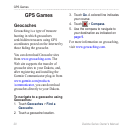

16 Dakota Series Owner’s Manual
Additional Tools
Additional Tools
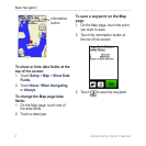
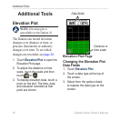
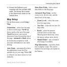
Elevation Plot
Elevation plot is
unavailable on the Dakota 10.
The Dakota can record elevation
changes over distance or time, or
pressure (barometric or ambient)
changes over time. To set which
changes are recorded, see page 28.
1. Touch Elevation Plot to open the
Elevation Plot page.
2. To adjust the distance or time
scale, touch the scale and then
touch
or .
3. To display elevation data, touch a
point on the plot. The time, date,
and elevation recorded at that
point are shown.
Elevation Plot Page
Data elds
Distance or
time scale
Changing the Elevation Plot
Data Fields
1. Touch Elevation Plot.
2. Touch a data type at the top of
the screen.
3. Select from the options listed
to replace the data type on the
screen.