


Garmin G1000 Cockpit Reference Guide for the Socata TBM 850
190-00708-02 Rev. A 49
Hazard Avoidance
Flight
Instruments EAS
Nav/Com/
XPDR/Audio AFCS GPS Nav
Flight
Planning Procedures
Hazard
Avoidance
Additional
Features
Abnormal
Operation
Annun/
Alerts Appendix Index
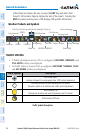
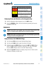
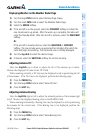
TERRAIN AWARENESS & WARNING SYSTEM (TAWS) DISPLAY
WARNING: The TAWS display shows supplemental information only. It should
not be used for navigation.
NOTE: Terrain data is not displayed when the aircraft latitude is greater than
75 degrees north or 60 degrees south.
NOTE: TAWS operation is only available when the G1000 is configured for a
TAWS-B installation.
Manual System Test
1)
While the TAWS-B Page is displayed, press the MENU Key.
2)
Turn the small FMS Knob to select ‘Test TAWS’.
3)
Press the ENT Key. During the test ‘TAWS TEST’ is displayed in the center
of the TAWS-B Page.
When all is in working order, “TAWS System Test, OK” is heard.
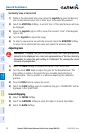
Display Terrain on the TAWS-B Page
1)
Turn the large FMS Knob to select the Map Page Group.
2)
Turn the small FMS Knob to select the TAWS-B Page.
3)
If desired, select the VIEW Softkey to access the ARC and 360 softkeys.
When the ARC Softkey is selected, a radar-like 120° view is displayed.
Select the 360 Softkey to return to the 360° default display.
4)
Rotate the Joystick clockwise to display a larger area or rotate counter-
clockwise to display a smaller area.
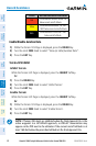
Color Terrain/Obstacle Location
Red
Terrain/Obstacle above or within 100’
below current aircraft altitude.
Yellow
Terrain/Obstacle between 100’ and
1000’ below current aircraft altitude.
Black
Terrain/Obstacle is more than 1000’
below aircraft altitude.