


Garmin G1000 Cockpit Reference Guide for the Socata TBM 850
190-00708-02 Rev. A
22
GPS Navigation
Flight
InstrumentsEAS
Nav/Com/
XPDR/AudioAFCSGPS Nav
Flight
PlanningProcedures
Hazard
Avoidance
Additional
Features
Abnormal
Operation
Annun/
AlertsAppendixIndex
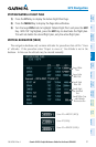
Since altitudes loaded with an arrival procedure are published only for turbojet
aircraft, the altitudes are displayed as white text indicating that the altitudes are
displayed for reference only. An arrival waypoint altitude may be used (or “designated”)
as is, or changed to a different altitude. An altitude is designated by pressing the FMS
Knob and turning the large FMS Knob to place the cursor on the desired altitude and
pressing the ENT Key or entering a different value and pressing the ENT Key. The
altitude is now displayed as blue text, indicating that the altitude is now designated to
give vertical speed and deviation guidance.
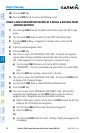
Approach waypoint altitude constraints are designated in the same way as
previously described for arrivals. These altitudes are also displayed as blue text after
not including the FAF. The FAF is always a “reference only” altitude and cannot be
designated, unless the selected approach does not provide vertical guidance. In this
case, the FAF altitude can be designated.
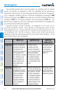
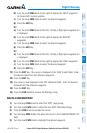
White Text Light Blue Text Light Blue
Subdued Text
Large Text
Altitude calculated by
the system estimating
the altitude of the
aircraft as it passes over
the navigation point.
This altitude is provided
as a reference and is
not designated to be
used in determining
vertical flight path
guidance.
Altitude has been
entered by the pilot.
Altitude is designated
for use in giving vertical
flight path guidance.
Altitude does not match
the published altitude
in navigation database
or no published altitude
exists.
The system cannot
use this altitude
in determining
vertical flight path
guidance.
Small Text
Altitude is not
designated to be used
in determining vertical
flight path guidance.
Altitude has been
retrieved from the
navigation database
and is provided as a
reference.
Altitude is designated for
use in giving vertical flight
path guidance. Altitude
has been retrieved from
the navigation database
or has been entered by
the pilot and matches a
published altitude in the
navigation database.
The system cannot
use this altitude in
determining vertical
flight path guidance.