


Garmin G1000 Cockpit Reference Guide for the Socata TBM 850
190-00708-02 Rev. A
46
Hazard Avoidance
Flight
InstrumentsEAS
Nav/Com/
XPDR/AudioAFCSGPS Nav
Flight
PlanningProcedures
Hazard
Avoidance
Additional
Features
Abnormal
Operation
Annun/
AlertsAppendixIndex
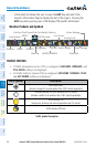
Displaying Traffic on the Traffic Map Page
1)
Turn the large FMS Knob to select the Map Page Group.
2)
Turn the small FMS Knob to select the second rectangular page icon.
3)
Select the NORMAL Softkey to begin displaying traffic. ‘OPERATING’ is
displayed in the Traffic Mode field.
4)
Select the ALT MODE Softkey to change the altitude volume. Select the
desired altitude volume by pressing the BELOW, NORMAL, ABOVE, or
UNREST (unrestricted) Softkey. The selection is displayed in the Altitude
Mode field.
5)
Select the STANDBY Softkey to place the system in the Standby Mode.
‘STANDBY’ is displayed in the Traffic Mode field.
6)
Rotate the Joystick clockwise to display a larger area or rotate counter-
clockwise to display a smaller area.
Displaying Traffic on the Navigation Map
1)
Ensure TAS is operating.
2)
With the Navigation Map displayed, select the MAP Softkey.
3)
Select the TRAFFIC Softkey. Traffic is now displayed on the map.
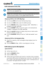
TERRAIN AND OBSTACLE PROXIMITY
NOTE: Terrain data is not displayed when the aircraft latitude is greater than
75 degrees north or 60 degrees south.
Displaying Terrain and Obstacles on the Terrain Proximity Page
1)
Turn the large
FMS
Knob to select the Map Page Group.
2)
Turn the small
FMS
Knob to select the last rectangular page icon.
3)
If desired, press the
VIEW
Softkey to access the
ARC
and
360
Softkeys.
When the
ARC
Softkey is pressed, a radar-like 120° view is displayed. Press
the
360
Softkey to return to the 360° default display.
4)
Rotate the
Joystick
clockwise to display a larger area or rotate counter-
clockwise to display a smaller area.