


Garmin G1000 Cockpit Reference Guide for the Socata TBM 850
190-00708-02 Rev. A
48
Hazard Avoidance
Flight
InstrumentsEAS
Nav/Com/
XPDR/AudioAFCSGPS Nav
Flight
PlanningProcedures
Hazard
Avoidance
Additional
Features
Abnormal
Operation
Annun/
AlertsAppendixIndex
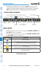
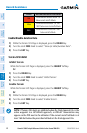
Color Terrain/Obstacle Location
Red
Terrain/Obstacle above or within 100’
below current aircraft altitude.
Yellow
Terrain/Obstacle between 100’ and
1000’ below current aircraft altitude.
Black
Terrain/Obstacle is more than 1000’
below aircraft altitude.
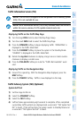
Enable/Disable Aviation Data
1)
While the Terrain-SVS Page is displayed, press the MENU Key.
2)
Turn the small FMS Knob to select “Show (or Hide) Aviation Data”.
3)
Press the ENT Key.
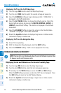
Terrain-SVS Inhibit
Inhibit Terrain
While the Terrain-SVS Page is displayed, press the INHIBIT Softkey.
Or
:
1)
Press the MENU Key.
2)
Turn the small FMS Knob to select ‘Inhibit Terrain’.
3)
Press the ENT Key.
Enable Terrain
While the Terrain-SVS Page is displayed, press the INHIBIT Softkey.
Or
:
1)
While the Terrain-SVS Page is displayed, press the MENU Key.
2)
Turn the small FMS Knob to select ‘Enable Terrain’.
3)
Press the ENT Key.
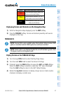
NOTE: If Terrain-SVS alerts are inhibited when the Final Approach Fix is the
active waypoint in a GPS WAAS approach, a LOW ALT annunciation may
appear on the PFD next to the altimeter if the current aircraft altitude is at
least 164 feet below the prescribed altitude at the Final Approach Fix.