


Garmin G1000 Cockpit Reference Guide for the Socata TBM 850
190-00708-02 Rev. A
Appendix
99
Flight
Instruments EAS
Nav/Com/
XPDR/Audio AFCS GPS Nav
Flight
Planning Procedures
Hazard
Avoidance
Additional
Features
Abnormal
Operation
Annun/
Alerts Appendix Index
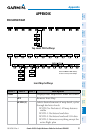
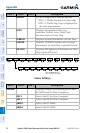
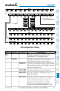
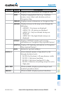
Level 1 Level 2
Description
TRAFFIC
Displays
TOPO
Displays topographical data (e.g., coastlines,
terrain, rivers, lakes) and elevation scale on
Navigation Map
TERRAIN
Displays terrain information on Navigation Map
AIRWAYS
Displays airways on the map; cycles through the
following:
airways are displayed
airways are displayed
airways are
displayed
airways are
displayed
NEXRAD
Displays NEXRAD weather and coverage
information on Navigation Map (optional feature)
XM LTNG
Displays XM lightning information on Navigation
Map (optional feature)
BACK
Returns to top-level softkeys
DCLTR (3)
Selects desired amount of map detail; cycles
through declutter levels:
DCLTR (No Declutter): All map features visible
DCLTR-1: Declutters land data
DCLTR-2: Declutters land and SUA data
DCLTR-3: Removes everything except the active
flight plan
SHW CHRT
terminal procedure charts
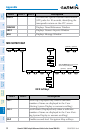
CHKLIST