


20
Reference
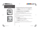
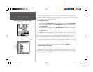
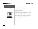
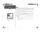
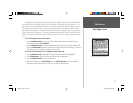
Status Page
Status Page
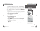
The GPSMAP 168 Sounder Status Page provides a visual reference of satellite acquisition, receiver
status, date, time and position coordinates. The status information will give you an idea of what the
receiver is doing at any given moment. The sky view and signal strength bars give you an indication of
what satellites are visible to the receiver and whether or not they are being tracked. The signal strength
is shown on a bar graph for each satellite, with the satellite number below. As the receiver locks
onto satellites, a signal strength bar will appear for each satellite in view, with the appropriate satellite
number (01-32) underneath each bar. The progress of satellite acquisition is shown in three stages:
• No signal strength bars— the receiver is looking for the satellites indicated.
• Light signal strength bars— the receiver has found the satellite(s) and is collecting data.
• Dark signal strength bars— the receiver has collected the necessary data and the satellite(s) are ready
for use.
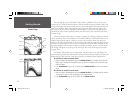
Each satellite has a data transmission that must be collected (light bar status) before that satellite
may be used for navigation (dark bar status). When the receiver is looking for a particular satellite,
the corresponding signal strength bar will be blank and the sky view indicator will not be highlighted.
Once the receiver has found the satellite, a light signal strength bar will appear, indicating that the
satellite has been found. When the receiver has collected data from the satellite and locked on, the
number in the sky view will appear highlighted and the status bar will become dark.
As soon as the GPSMAP 168 Sounder has collected the necessary data from the best satellites in
view to calculate a fi x, the status fi eld will indicate a 2D or 3D status. The unit will then update the
position, date and time.
You can use the sky view to help determine if any satellites are being blocked, and whether you
have a current position fi x (indicated by a ‘2D Navigation’ or ‘3D Navigation’ in the status fi eld).
The sky view shows a bird’s-eye view of the position of each satellite relative to the receiver’s last
known position. The outer circle represents the horizon (north up), the inner circle 45º above the
horizon, and the center point a position directly overhead. You can also set the sky view to a ‘Track Up’
confi guration, causing the top of the sky view to align along your current track heading.
Position Coordinates
Date
Time
Sky View
Signal Strength Bars
Receiver Status
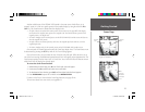
Ready for use
Collecting data
Searching for signal
DGPS
Status
Accuracy
DOP
168 Manual Part 1.indd 20 11/18/2002, 3:36:28 PM