


106
Appendix H
Understanding the Chart
Whiteline
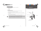
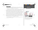
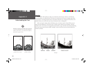
The GPSMAP 168 Sounder can help you to determine if the bottom is hard or soft. When the
sonar soundwaves are refl ected back by the bottom, a hard bottom will return a stronger signal than
a soft bottom. The stronger bottom return, the wider the bottom layer is displayed. The unit uses the
whiteline function to make this bottom layer information easier to distinguish.
When viewing the display without Whiteline active, the bottom return is black. While you can
make some determination of the bottom type, the black return makes this more diffi cult. With the
whiteline active, the bottom return appears layered in shades of gray and black and makes determining
the bottom type easier and more reliable. Example 3 shows the bottom return with and without the
whiteline activated.
)
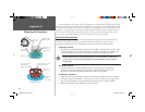
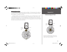
Whiteline can also help you to determine the type of bottom
structure that is displayed on the chart. By determining the
hardness of the structure, you can make a better informed
decision on the type of structure.
Structure is hard—
probably a rock or stump
Structure is soft—
probably a mud pile
Example 3.
168 Manual Part 2.indd 106 11/18/2002, 3:38:17 PM