


28
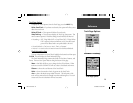
Reference
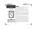
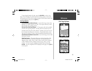
Trip Computer Options — Tracks
Vertical Tab Data Fields
T otal Ascent —
The Total Ascent fi eld will show the Total Ascent of the trip in
the units selected. This fi eld indicates the total off all ascents.
Total Descent —
The Total Descent fi eld will show the Total Descent of the
trip in the units selected. This fi eld indicates the total off all descents.
As an example, if you ascend 100 ft, descend 20 ft, ascend 50 ft and descend
30 ft, the Total Ascent would be 150 ft and Total Descent would be 70 ft.
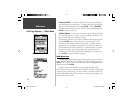
Max Ascent —
The Max Ascent fi eld shows the maximum rate of ascent.
Max Descent —
The Max Descent fi eld shows the maximum rate of descent.
Avg Ascent —
The Avg Ascent fi eld shows the average rate of ascent.
Avg Descent —
The Avg Descent fi eld shows the average rate of descent.
Max Elevation —
The Max Elevation fi eld shows the Maximum Elevation for
the trip.
Min Elevation —
The Min Elevation fi eld shows the Minimum Elevation for
the trip.
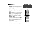
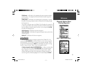
Vertical Tab Options
Reset Trip —
This option will reset all fi elds except Max Elevation to zero.
Reset Max Elevation —
This option will reset the Max Elevation fi eld to zero.
Reset All —
This option will reset all Vertical & Horizontal Tab fi elds to zero.
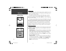
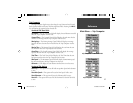
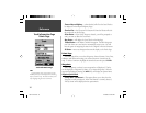
Tracks
The Tracks Page displays the amount of Track Memory used, will allow you to
‘Save’ or ‘ Clear’ the current Track Log, shows how many Saved Tracks are unused
and displays a list of any Saved Tracks.
Save —
When ‘Save’ is selected, you can choose how much of the track log
you wish to save. Make a selection, then press ENTER to save the selection.
Clear —
The ‘Clear’ Button will clear the Track Log. If the Map Page is
becoming cluttered with tracks, clearing the Track Log will clean up the map.
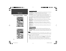
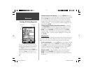
Horizontal Tab Options
Vertical Tab Options
76S manual.indd 28 4/23/2002, 3:03:58 PM