


19
Getting Started
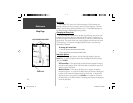
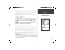
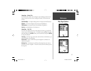
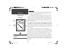
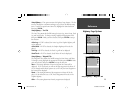
Setup Map — ‘Road’ Tab
The ‘Road’ Tab contains the ‘Text’ and ‘Zoom’ settings for Local Road Names
and ‘Zoom’ settings for Freeway, Highway, and Local Roads. To change a
setting, highlight the appropriate fi eld then press ENTER. Make your new
selection, then press ENTER to accept the selection.
Freeway —
Interstate and U.S. Highways
Highway —
State Highways and Local Highways
Local Roads —
All Other Roads
Local Road Names —
Name Labels for Local Roads
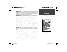
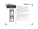
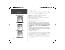
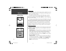
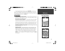
Setup Map — ‘Other’ Tab
The ‘Other’ Tab contains the ‘Text’ and ‘Zoom’ settings for Railroad and an
On/Off setting for the Accuracy Circle. To change a setting, highlight the
appropriate fi eld then press ENTER. Make your new selection, then press
ENTER to accept the selection.
Railroad —
controls the display of railways lines on the Map Page.
Accuracy Circle —
The Accuracy Circle is displayed around the Location Tri-
angle on the Map Page. The Accuracy Circle depicts the estimated accuracy
of the location. If your current location is matched to a road, no Accuracy
Circle will be displayed.
Heading Line —
If the Heading line is ‘On’, a line showing your current head-
ing will be projected on the map from the current location. The Heading line
is a thin black line.
Lock to Roads —
If ‘Lock to Roads’ is ‘On’, the unit will try to match your
location to a road.
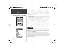
Setup Map — ‘Other’ Tab
Setup Map — ‘Road’ Tab
Map Page Options
Reference
76S manual.indd 19 4/23/2002, 3:03:50 PM