


15
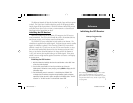
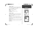
Getting Started
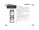
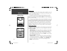
Colors —
This option gives you the ability to confi gure the map to display
either land or water as white. If you select ‘Land’ the land portion of the
display will be lighter in color than the water. If you select ‘Water’ the water
portion of the display will be lighter in color than the land.
Auto Zoom —
This option allows you to have the map automatically zoom in
on a waypoint as you approach it.
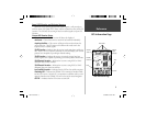
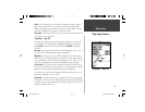
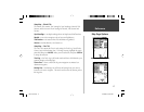
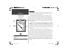
Setup Map — ‘Map’ Tab
The ‘Map’ Tab contains settings for the Basemap, MapSource, Lat Lon Grids,
and Grid Labels. To change a setting, highlight the appropriate fi eld then
press ENTER. Make your new selection then press ENTER to accept the
selection.
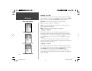
Basemap —
This option allow you to turn the Basemap data ‘On’ or ‘Off’. If
you select ‘Off’, the Basemap will no longer be displayed.
MapSource —
This option is only available if Mapsource CD data has been
loaded into the unit. If MapSource data is available, you can choose whether
or not to display the data on the map by selecting either ‘On’ or ‘Off’. If you
select ‘Off’, the MapSource data will not be displayed on the Map Page.
Lat Lon Grid —
Lat Lon Grids will be displayed in smaller increments as the
Zoom Level on the Map Page is decreased. The ‘Zoom’ setting for this option
determines when the grids will begin displaying on the Map Page.
If you select ‘Auto’, and have the Basemap or MapSource options set to ‘ON’,
the unit will not display a Lat Lon Grid.
Grid Labels —
This option allows you to display the coordinates on the grid.
You must have the ‘Lat Lon Grid’ displayed for ‘Grid Labels’ to be displayed. If
you select ‘Auto’, and have the Basemap or MapSource options set to ‘ON’, the
unit will not display Grid Labels.
Setup Map — ‘Map’ Tab
Map Page Options
Reference
76S manual.indd 15 4/23/2002, 3:03:49 PM