


10
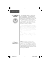
Selecting a Page
All of the information needed to operate the eTrex is
found on four main “pages” (or display screens). These
pages are the Satellite, Map, Pointer, and Menu.
Simply press the PAGE Button to switch between
pages.
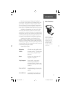
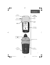
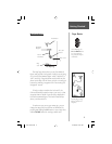
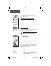
Satellite Page Basics
The Satellite Page shows the eTrex gathering all the
necessary satellite information in order to work. There are
two display options on the Satellite Page, Normal Skyview
and Advanced Skyview. Normal Skyview shows you (in
animation), the satellites, satellite signal strength, and the
eTrex’s estimated location accuracy.
To activate the Advanced Skyview page, simply press
ENTER when on the Satellite Page, select ‘Advanced
Skyview’ and press ENTER again. This page displays
the numbered satellites the eTrex is using, their proxim-
ity to your current position, and their individual signal
strengths. To determine the location of the satellites
being used around you, the outer circle of the display
represents the horizon and the center represents the sky
The “READY TO
NAVIGATE” message
must appear before you
can begin using your
eTrex to navigate.
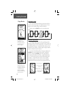
Page Basics
Getting Started
Status Message
Satellites
Location Accuracy
(estimated)
Satellite Signal
Strength Bars
Map
Navigation
MenuSatellite
PAGE
PAGE
PAGE
PAGE
PAGE
PAGE
PAGE
PAGE
Pressing ENTER on the
Advanced Skyview Page
also offers the options of
Orienting the Sky Ahead
or Northward, Setup
Display (backlighting/
contrast), and returning
to Normal Skyview.
Normal Skyview
Advanced Skyview
etrex manual.indd 10 2/19/2003, 1:37:00 PM