


GPSMAP 400/500 Series Owner’s Manual 55
Appendix
WAAS Accuracy:
Position: <10 ft. (3 m), 95% typical*
Velocity: 0.05 m/sec steady state
Dynamics: 6 g
Power
Power Source: 10–32 Vdc
GPSMAP 421/421s GPSMAP 451/451s
GPSMAP 521/521s GPSMAP 526/526s
GPSMAP 551/551s GPSMAP 556/556s
Power Source: 10–35 Vdc
GPSMAP 420/420s GPSMAP 450/450s
GPSMAP 520/520s GPSMAP 525/525s
GPSMAP 550/550s GPSMAP 555/555s
Usage: 15 W max at 13.8 Vdc
Fuse:
AGC/3AG - 3.0 A
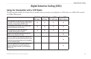
Sonar
Power: 1 kW Transducer, 1,000 W (RMS),
8,000 W (peak to peak)*;
Dual Frequency, 500 W (RMS), 4,000 W (peak to peak);
Dual Beam, 400 W (RMS), 3,200 W (peak to peak)
Frequency:
50/200 kHz (dual frequency and 1 kW), 80/200 kHz
(dual beam)
Depth: 2,500 ft. (762 m) (1 kW), 1,500 ft. (457 m) (dual frequency),
900 ft (274 m) (dual beam)**
*1 kW transducers are supported by the GPSMAP 525s/526s/
555s/556s units only.
**Depth capacity is dependent on water salinity, bottom type,
and other water conditions.
Alarms and Messages
The unit uses an on-screen message system to alert you to unit
operating characteristics. When a message appears, press MENU to
acknowledge the message.
Accuracy Alarm
—the GPS accuracy has fallen outside of the user-
set value.
AIS: Dangerous Target
—shows the MMSI (Maritime Mobile
Service Identity) of the dangerous target.
Alarm Clock
—the alarm clock has sounded.
Anchor Drag Alarm
—you have drifted out of the specied distance
range.
Antenna Input is Shorted
—a part of the antenna wiring is
contacting the chassis.