


longitude in degrees and minutes, with options for degrees,
minutes and second, degrees only, or one of several grid
formats.
Map datum is a math model which depicts a part of the surface
of the earth. Latitude and longitude lines on a paper map are
referenced to a specific map datum.
1
Find out which map datum and position format was used
when the original waypoint was created.
If the original waypoint was taken from a map, there should
be a legend on the map that lists the map datum and position
format used to create that map. Most often this is found near
the map key.
2
On the chartplotter, select Settings > Units.
3
Select the correct map datum and position format settings.
4
Create the waypoint again.
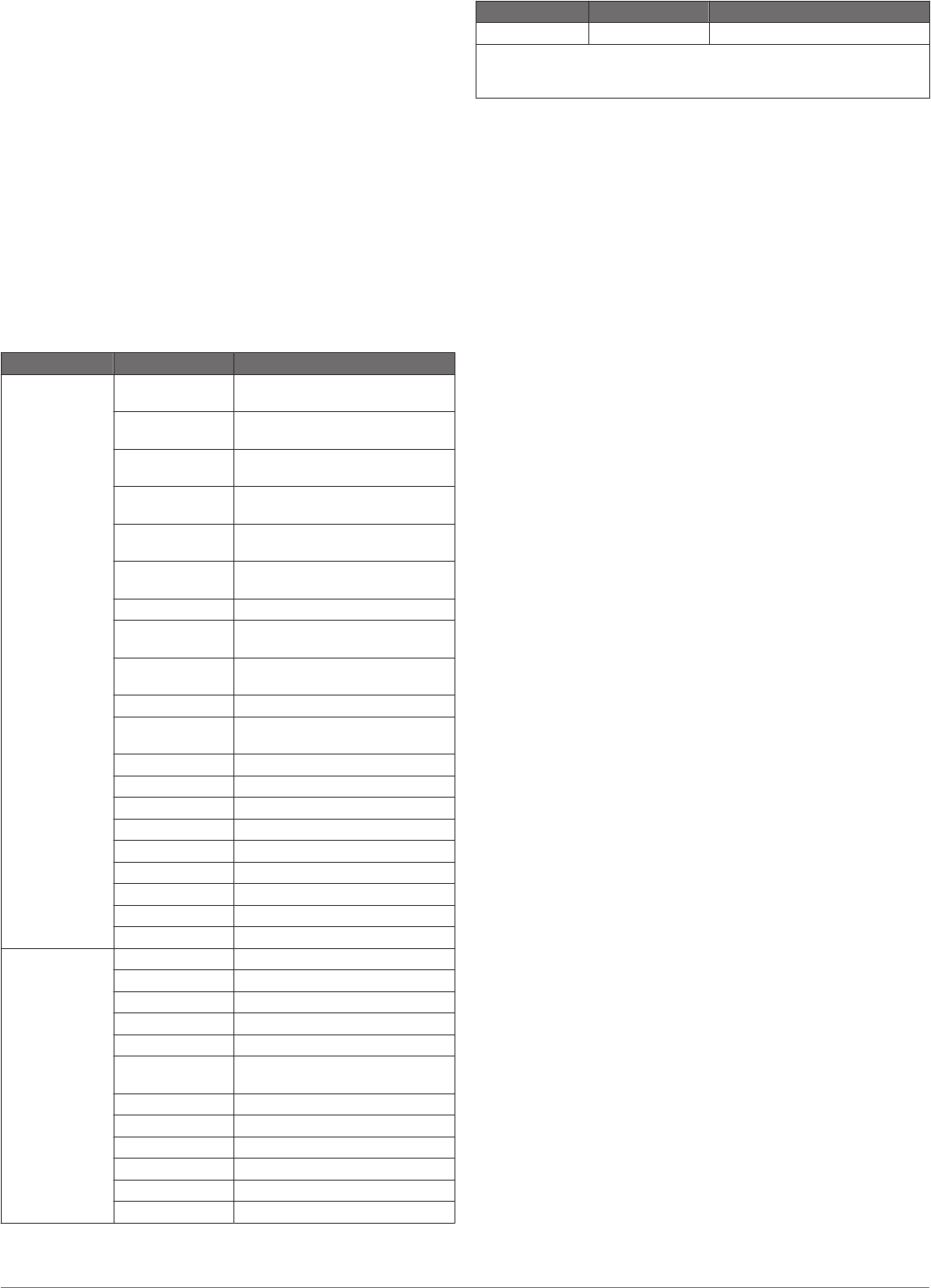
NMEA 0183 Information
Type Sentence Description
Transmit GPAPB APB: Heading or track controller
(autopilot) sentence "B"
GPBOD BOD: Bearing (origin to
destination)
GPBWC BWC: Bearing and distance to
waypoint
GPGGA GGA: Global positioning system
fix data
GPGLL GLL: Geographic position
(latitude and longitude)
GPGSA GSA: GNSS DOP and active
satellites
GPGSV GSV: GNSS satellites in view
GPRMB RMB: Recommended minimum
navigation information
GPRMC RMC: Recommended minimum
specific GNSS data
GPRTE RTE: Routes
GPVTG VTG: Course over ground and
ground speed
GPWPL WPL: Waypoint location
GPXTE XTE: Cross track error
PGRME E: Estimated error
PGRMM M: Map datum
PGRMZ Z: Altitude
SDDBT DBT: Depth below transducer
SDDPT DPT: Depth
SDMTW MTW: Water temperature
SDVHW VHW: Water speed and heading
Receive DPT Depth
DBT Depth below transducer
MTW Water temperature
VHW Water speed and heading
WPL Waypoint location
DSC Digital selective calling
information
DSE Expanded digital selective calling
HDG Heading, deviation, and variation
HDM Heading, magnetic
MWD Wind direction and speed
MDA Meteorological composite
MWV Wind speed and angle
Type Sentence Description
VDM AIS VHF data-link message
You can purchase complete information about National Marine
Electronics Association (NMEA) format and sentences from: NMEA,
Seven Riggs Avenue, Severna Park, MD 21146 USA (www.nmea.org)
Software License Agreement
BY USING THE DEVICE, YOU AGREE TO BE BOUND BY THE
TERMS AND CONDITIONS OF THE FOLLOWING SOFTWARE
LICENSE AGREEMENT. PLEASE READ THIS AGREEMENT
CAREFULLY.
Garmin Ltd. and its subsidiaries (“Garmin”) grant you a limited
license to use the software embedded in this device (the
“Software”) in binary executable form in the normal operation of
the product. Title, ownership rights, and intellectual property
rights in and to the Software remain in Garmin and/or its third-
party providers.
You acknowledge that the Software is the property of Garmin
and/or its third-party providers and is protected under the United
States of America copyright laws and international copyright
treaties. You further acknowledge that the structure,
organization, and code of the Software, for which source code is
not provided, are valuable trade secrets of Garmin and/or its
third-party providers and that the Software in source code form
remains a valuable trade secret of Garmin and/or its third-party
providers. You agree not to decompile, disassemble, modify,
reverse assemble, reverse engineer, or reduce to human
readable form the Software or any part thereof or create any
derivative works based on the Software. You agree not to export
or re-export the Software to any country in violation of the export
control laws of the United States of America or the export control
laws of any other applicable country.
22 Appendix