


Restoring Backup Data to a Chartplotter
1
Insert a memory card into a card reader that is attached to
the computer.
2
Copy a backup file from the computer to the memory card,
into a folder named Garmin\UserData.
3
Insert a memory card into the card slot.
4
Select User Data > Manage Data > Data Transfer >
Replace from Card.
Saving System Information to a Memory
Card
You can save system information to a memory card as a
troubleshooting tool. A product support representative may ask
you to use this information to retrieve data about the network.
1
Insert a memory card into the card slot.
2
Select Settings > System > System Information > Garmin
Devices > Save to Card.
3
If necessary, select the memory card to save system
information to.
4
Remove the memory card.
Device Configuration
Turning On the Chartplotter Automatically
You can set the chartplotter to turn on automatically when the
power is applied. Otherwise, you must turn on the chartplotter by
pressing .
Select Settings > System > Auto Power.
NOTE: When Auto Power is On, and the chartplotter is
turned off using , and power is removed and reapplied
within less than two minutes, you may need to press to
restart the chartplotter.
System Settings
Select Settings > System.
Display: Adjusts the backlight brightness and color scheme.
Beeper: Turns on and off the tone that sounds for alarms and
selections.
GPS: Provides information about the GPS satellite settings and
fix.
Auto Power: Turns on the device automatically when power is
applied (Turning On the Chartplotter Automatically ).
Language: Sets the on-screen text language.
Speed Sources: Sets the source of the speed data used to
calculate true wind speed or fuel economy. Water speed is
the speed reading from a water-speed sensor, and GPS
speed is calculated from your GPS position.
System Information: Provides information about the device and
the software version.
Simulator: Turns on the simulator and allows you to set the
speed and simulated location.
Display Settings
Not all options are available on all models.
Select Settings > System > Display.
Backlight: Sets the backlight level.
Color Mode: Sets the device to display day or night colors.
Screenshot Capture: Allows the device to save images of the
screen.
GPS Settings
Select Settings > System > GPS.
Skyview: Shows the relative position of GPS satellites in the
sky.
WAAS/EGNOS: Turns on or off WAAS (in North America) or
EGNOS (in Europe), which can provide more-accurate GPS
position information. When using WAAS or EGNOS, the
device may take longer to acquire satellites.
Speed Filter: Averages the speed of your vessel over a short
period of time for smoother speed values.
Source: Allows you to select the preferred source for GPS.
Viewing the Event Log
The event log shows a list of system events.
Select Settings > System > System Information > Event
Log.
Viewing System Software Information
Select Settings > System > System Information >
Software Information.
My Vessel Settings
NOTE: Some settings and options require additional charts or
hardware.
Select Settings > My Vessel.
Keel Offset: Offsets the surface reading for the depth of a keel,
making it possible to measure depth from the bottom of the
keel instead of from the transducer location (Setting the Keel
Offset).
Temp. Offset: Compensates for the water temperature reading
from a NMEA 0183 water-temperature sensor or a
temperature-capable transducer (Setting the Water
Temperature Offset).
Vessel Type: Enables some chartplotter features based on the
boat type.
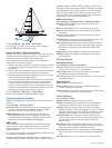
Setting the Keel Offset
You can enter a keel offset to compensate the surface reading
for the depth of a keel, making it possible to measure depth from
the bottom of the keel instead of from the transducer location.
Enter a positive number to offset for a keel. You can enter a
negative number to compensate for a large vessel that may
draw several feet of water.
1
Complete an action, based on the location of the transducer:
• If the transducer is installed at the water line
À
, measure
the distance from the transducer location to the keel of the
boat. Enter this value in steps 3 and 4 as a positive
number.
• If the transducer is installed at the bottom of the keel
Á
,
measure the distance from the transducer to the water
line. Enter this value in steps 3 and 4 as a negative
number.
Device Configuration 19