


15
Introduction
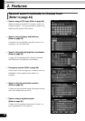
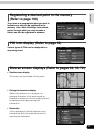
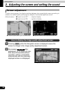
6 Vehicle position mark
The present location and the vehicle direction are displayed.
7 Scale display
The reduction scale of the map being displayed is indicated.
The length of the appearing in the screen above represents 300ft.
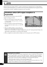
8 GPS mark
This mark will appear when utilizing the absolute positioning data from the GPS satellite.
• See page 16 for information concerning this mark's display. There may be misalignments
depending on the satellite conditions.
9 Distance remaining display
The distance from the present location to the destination is indicated.
• While route guidance is in progress, the distance calculated from the route now being
taken to the destination is indicated.
• When deviating from the set route, the distance to the destination in a straight line is
indicated.
• Refer to "Switching the required time/distance remaining display" on page 94 for
information on how to switch the remaining distance display.
0 Required time display/destination direction mark
The following marks appear depending on the situation.
■ Required time display
While route guidance is in progress, the required time up to the destination is indicated.
• Refer to "Setting the required time display" on page 87 for information concerning the
required time.
■ Destination direction mark
When deviating from the set route, the direction towards the destination is displayed.
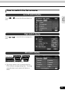
A Cursor mark
This mark is indicated on the map retrieved by a search or by scrolling.
To scroll, simply touch the map (on a spot other than the touch switches on the screen).
B Cursor position name display
The name of the cursor position on the map is displayed (approx. 6 seconds).
Except for some parts describing certain functions, this manual uses normal north-up
map screen illustrations to describe the device's functions.
"Map touched" appears signifying that the map was directly touched (on spots other
than touch switches).