


16
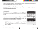
SATELLITES: Displays the available GPS satellite relative positions and signal strength, along with an indication of the
overall satellite reception quality (“STRONG”, “GOOD”, “WEAK”).
BATTERY LEVEL: Displays the remaining battery power level as a percentage.
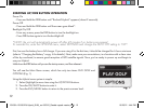
RESUME PLAY: Returns to the distance display for the current hole. Any edits you made via the Map Golf Hole option
will be shown instead of the original distance.
EXIT: Exits the Play Golf Menu and returns to the Main Menu.
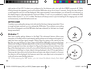
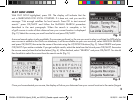
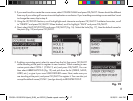
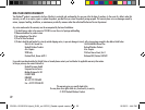
OPTIONS MENU
From the Main Menu, select (press the DOWN button to highlight) OPTIONS and
press OK/SHOT to access the following features and settings in the Options Menu
(Fig. 14):
MAP COURSE: This feature allows you to customize existing course data (changing
front/back/center locations for a hole, or adding new points like bunkers, hazards,
etc.), or you can even create an entire new file of course data (if you want to map
a course not yet in the iGolf database). Begin by highlighting “MAP COURSE” and
pressing OK/SHOT. Here’s how to use the MAP COURSE feature:
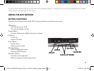
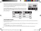
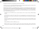
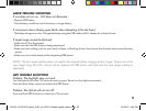
1. Select EDIT COURSE to customize an existing course, or select CREATE
COURSE to begin setting up an entirely new set of data, and press OK/SHOT
(Fig. 15). Choose the course name from the list if you’re editing an existing
one, or select NEW COURSE 1 if you’re creating a new course data file (then
enter the state name).
Fig. 14
Fig. 15
201951+201951EU Hybrid_5LIM_rev102312_Geodis repack version.indd 16 10/25/12 4:44 PM