


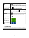
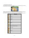

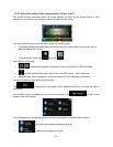
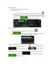

Zooming in and out
,
Changes how much of the map is displayed on the
screen.
Your software uses high-
quality vector maps that let
you examine the map at various zoom levels, always
with optimiz
ed content. It always displays street
names and other text with the same font size,
never
upside-
down, and you only see the streets and
objects that you need.
Map scaling has a limit in 3D map view
mode. If you
zoom out further, the map switches to 2D view mode.
Tap the button once to modify the view in large
steps, or tap and hold the b
utton to modify it
continuously and smoothly.
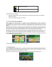
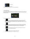
Tilting up and down
,
Changes the vertical view angle of the map in 3D
mode.
Tap the button once to modify the view in large
steps, or tap and hold the button to modify it
continuously and smoothly.
Rotating left and right
,
Changes the horizontal view angle of the map.
Tap the button once to modify the view in large
steps, or tap
and hold the button to modify it
continuously and smoothly.
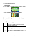
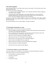
Compass
, ,
Tap this button to cycle between a 3D perspective
and two 2D top-down map view modes.
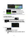
Location information
Tap this button to open a new screen with
information about the selected map point, the Cursor.
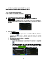
Return to normal
navigation
Tap this button to move the map back to follow the
current GPS position
. Automatic map rotation is also
re-enabled.
The map manipulation buttons disappear and
navigation continues.
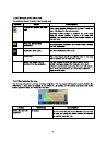
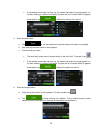
Additional options
Tap this button to open a list of additional features
like saving the Cursor
as an Address Book entry, or
searching for Places around the Cursor.
Select destination
Tap this button to select the Cursor
as a new
destination.
18