


2.2.2 Position markers
2.2.2.1 Vehimarker and Lock-on-Road
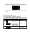
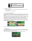
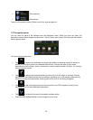
When your GPS position is available, the software marks your current position with the Vehimarker. By
default, this marker is a blue arrow, but you can change this icon in Settings.
When on-road navigation is selected, the Vehimarker may not show your exact GPS position and
heading. If roads are near, it is aligned to the nearest road to suppress GPS position errors, and the
direction of the icon is aligned to the direction of the road.
If you select off-road navigation: The Vehimarker is at your exact GPS position. The direction of the icon
shows your current heading.
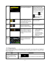
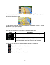
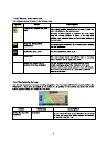
2.2.2.2 Selected map location (Cursor) and selected map object
You can mark a map location in the following ways:
• Tap the map when navigating,
• Tap the map when you are asked to confirm the destination at the end of a search, or
• Tap the map in Find on Map (page 47)
When a map location is selected, the Cursor appears at the selected point on the map. The Cursor is
displayed with a radiating red dot (
) to make it visible at all zoom levels.
The location of the Cursor can be used as the destination of the route, a new alert point, you can search
for Places around it, or you can save this location as one of your Favorite destinations.
You can also select some of the objects on the map. If you tap the map at the icon of a Place of Interest
or an alert point, the object will be selected (you see a red circling border around the object), and you can
get information about this object or use it as a route point.
2.2.3 Objects on the map
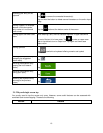
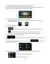
2.2.3.1 Streets and roads
The software shows the streets in a way that is similar to how the paper road maps show them. Their
width and colors correspond to their importance: you can easily tell a freeway from a small street.
13