


2 Overview
8 Trimble R7/R8 GPS Receiver User Guide
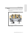
Trimble R7 Operation
2.1 Introduction
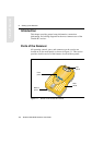
This chapter introduces the Trimble R7 GPS receiver. This receiver is
designed for GPS surveying applications. The receiver features
one-touch logging for ease of use, and five LEDs that let you monitor
the survey in progress and the available battery capacity.
The Trimble R7 tracks GPS satellites on both the L1 and L2
frequencies to provide precise position data for land survey
applications. The receiver records GPS data on an internal
CompactFlash card and makes all data available through serial or USB
ports.
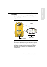
You can use the Trimble R7 alone by logging data internally, or as part
of the GPS Total Station® system, which logs GPS data from the
receiver to a Trimble controller running the Trimble Survey
Controller™ or Trimble Survey Pro™ software.
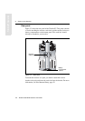
2.2 Features
The receiver provides the following features:
• Trimble R-track technology, which allows the receiver to track
the L2 Civil signal (L2C)
• Centimeter-accuracy real-time positioning with RTK/OTF data,
and up to 10 Hz position updates
• Submeter-accuracy real-time positioning using pseudorange
corrections
• Adaptive dual-frequency RTK engine
• WAAS/EGNOS capability (Wide Area Augmentation
System/European Geo-Stationary Navigation System)
• Automatic OTF (on-the-fly) initialization while moving
• 1PPS (One Pulse Per Second) output
• Dual event-marker input