


Trimble ThunderBolt E GPS Disciplined Clock User Guide 81
Trimble Standard Interface Protocol A
Report Packet 0x8F-AC
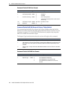
• Bit 8: When 1, indicates that The receiver is operating in one of its test modes (see
packet 0x8E- A4.)
• Bit 9: When 1, indicates that the accuracy of the position used for time only fixes is
questionable. This alarm may indicate that the unit has been moved since the unit
completed the last self-survey. If this alarm persists, re-survey the position of the unit.
Minor Alarms (cont.) • Bit 10: When 1, indicates that at reset, one or more EEPROM segments were found to
be corrupt and had to be set to factory default settings. Use packet 0x3F-11 / 5F-11 to
retrieve details about which segments were corrupt and to clear this bit.
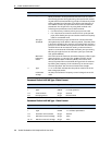
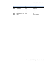
GPS Decoding Status This field indicates the decoding status of the GPS receiver.
Disciplining Activity This field indicates the current activity of the disciplining mechanism.
PPS Offset This field carries the estimate of the offset of the PPS output relative to UTC or GPS as
reported by the GPS receiver in nanoseconds. Positive values indicate that the receiver's
PPS is coming out late relative to GPS or UTC.
Frequency Offset This field carries the estimate of the frequency offset of the 10MHz output relative to
UTC or GPS as reported by the GPS receiver in ppb (parts-per-billion.) Positive values
indicate that the receiver's clock is running slow relative to GPS or UTC.
DAC Value This field shows the numeric value of the DAC used to produce the voltage that controls
the frequency of the 10MHz oscillator.
DAC Voltage This field shows the voltage output of the DAC.
Temperature This field shows the temperature (in Celsius) as reported by the receiver's on-board
temperature sensor.
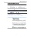
Latitude This field carries the latitude of the position being shown. The units are in radians and
vary from -pi/2 to +pi/2. Negative values represent southern latitudes. Positive values
represent northern latitudes.
Longitude This field carries the longitude of the position being shown. The units are in radians and
vary from -pi to +pi. Negative values represent western longitudes. Positive values
represent eastern longitudes.
Altitude This field carries the altitude of the position being shown. The units are in meters (WGS-
84.)
PPS Quantization
Error
This field carries the PPS quantization error in units of nanoseconds of an internal PPS
signal. This value is not useful on a ThunderBolt E since the PPS output is derived from a
disciplined oscillator and therefore does not have any quantization error
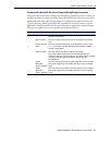
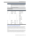
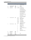
Byte Item Type Value Description
0 Subcode UINT8 0xAC
Receiver Mode UINT8 0 Automatic (2D/3D)
1 Single Satellite (Time)
3 Horizontal (2D)
4 Full Position (3D)
7 Over-Determined Clock
2 Disciplining Mode UINT8 0 Normal (Locked to GPS)
1Power Up
2 Auto Holdover
3 Manual Holdover
4 Recovery
Data field Description