


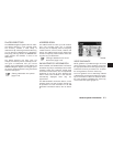

DISPLAY OF CURRENT VEHICLE
LOCATION
This navigation system combines the data ob-
tained from the vehicle (by gyro sensor) and from
GPS (Global Positioning System) satellites to
calculate the current location of the vehicle. This
position is then displayed throughout route guid-
ance to a destination.
WHAT IS GPS (Global Positioning
System)?
GPS is a position detecting system that uses
satellites deployed by the U.S. government. This
navigation system receives radio signals from
three or more different satellites that orbit
13,049 miles (21,000 km) above the earth in
space, and detects the position of the vehicle by
utilizing the principle of triangulation.
DETAILED MAP COVERAGE (MCA)
FOR THE NAVIGATION SYSTEM
This system is designed to help you reach your
destination, and also performs other functions as
outlined in this manual. However, you, the driver,
must use the system safely and properly. Infor-
mation concerning road conditions, traffic signs
and the availability of services may not always be
up-to-date. The system is not a substitute for
safe, proper, and legal driving.
Map data is available on the provided SD-card.
For information about the map SD-card, contact
a NISSAN dealer.
Map data includes 2 types of areas: “Detailed
coverage areas” providing all detailed road data
and other areas showing “Main roads only”.
NOTE:
Detailed map data is not available in many
areas and is generally limited to select ma-
jor metropolitan areas.
WHEN A GRAY ROAD IS DIS-
PLAYED ON THE MAP
● Route calculation may not be possible when a
destination or the current vehicle location is
near a gray road.
● Route guidance (enlarged view and voice
guidance) may not be done at the intersection
where the road your vehicle is driving on and a
gray road intersect.
● Places information and street names near
gray roads are not contained in the map data.
● The NISSAN Navigation System may not cal-
culate a route if the current vehicle location is
too far away from the destination. In this case,
please divide your trip by selecting one or two
intermediate destinations.
● To reach your destination, refer to the map
screen. Always follow actual roads and regu-
lations and drive safely.
● The suggested route may not be the shortest,
nor are other circumstances such as traffic
jams considered unless the XM NavTrafficா is
active.
● Because of the inevitable difference in road
conditions and circumstances between the
time you use this system and the time the in-
formation was produced for the map data,
there may be discrepancies in roads and
regulations. In such cases, follow the actual
information available.
● During route calculation, the map will not
scroll, however the vehicle icon will move with
the actual vehicle’s movement.
● In some cases, after the calculation is
complete, the calculated route may not be im-
mediately displayed.
● If you scroll the map while the suggested
route is being drawn, it may take more time to
finish drawing.
CURRENT VEHICLE LOCATION ROUTE CALCULATION
6-4 General system information