


31
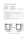
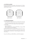
4.15 RINGS
The range rings can be turned to on or off via this menu.
4.16 POSITION
Select this option to display the ship’s position (derived from a navaid input).
This function allows selection of ship’s position in latitude/longitude (LL), time
difference (TD) position, you may also display waypoint (WPT) as a LL posi-
tion in place of your own position data. This menu also removes this data from
display. To highlight the required sub-function, move the cursor to it with the
JOYSTICK, then press JOYSTICK to activate it.
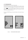
4.17 WAYPOINT
If the radar is interfaced with a LORAN or GPS with the necessary data output,
a waypoint symbol can be made to appear on the radar screen by activating the
WAYPOINT function in the DISPLAY menu. Numeric data, showing the
waypoint’s bearing, range, and time-to-go appear at the bottom right corner on
the screen.
4.18 SELECTION OF DATA FORMATS
This function selects the units and formats for the SHM, EBL, CURSOR and
WAYPOINT data.
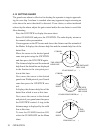
It can be displayed in degrees True (T) or magnetic (M) and is indicated by
these letters on screen. The Ship’s Head Marker is always displayed as zero
degrees.
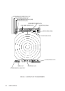
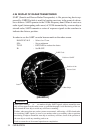
4.19 TRAIL
This feature allows the operator to see the past history of target movement as an
after-glow, or trail behind moving targets. The “glow-time” of these “trails”
and - hence - the amount of display time which they occupy, can be set to
“short” or “long”.
OPERATION