


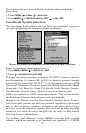
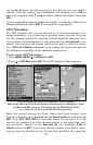

125
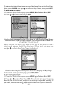
ner begins flashing. Use the arrow keys to select the box you want to
change. With the display box highlighted and flashing, press
ENT to
open a list of options. Scroll ↑ and ↓ to select a different data option, then press
ENT.
You can repeat these steps to change the display in another box. When all the
changes are
finished, press EXIT to return to the page display.
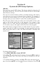
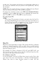
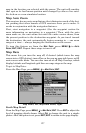
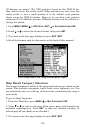
GPS Simulator
The GPS simulator lets you use the unit as if you were outdoors navi-
gating somewhere. It's a great way to practice using your unit. You can
set the starting location by entering latitude/longitude (Starting Posi-
tion) or from a stored waypoint or map place location (
CHOOSE START com-
mand). You can steer and change speed on the map by using the arrow
keys (
STEER WITH ARROWS command) or by setting the track and speed in
the dialog boxes provided on the simulator menu screen.
To get to the GPS Simulator:
1. Press
MENU|MENU|↓ to GPS SETUP|ENT.
2. Press ↓ to
GPS SIMULATOR|ENT. The GPS Simulator Menu appears.
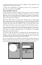
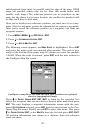
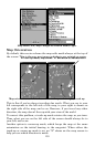
GPS Setup Menu, left; GPS Simulator menu, center.
Map Page showing Track and Speed steering arrow indicators, right.
In this example, you are "traveling" across Mudisland Point
on a track of 19º at a speed of 50 miles per hour.
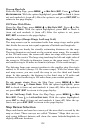
Make the desired settings for Track, Speed and Start location, then
turn the simulator on by highlighting the
SIMULATOR ON box and pressing
ENT. Press EXIT|EXIT|EXIT to erase this menu. (If you want, you can
turn on the simulator and the steering arrows at the same time with
one keystroke. Instead of the
SIMULATOR ON box, highlight STEER W/
A
RROWS and press ENT.) A message and tone appear periodically, warn-
ing you that the simulator is on. To turn the simulator off, repeat the