


80
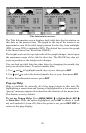
2. Press ↓ or ↑ to select Data Type|press → or ← to select Data
Size|
ENT
.
The data will be shown in the new font size. To return to the previ-
ous page, press
EXIT
|
EXIT
.
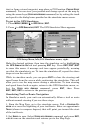
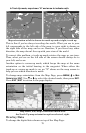
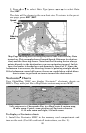
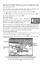
Map Page showing boat cruising Keystone Lake with Overlay Data
turned on. This example shows Ground Speed, Distance (to destina-
tion) and the Steering Arrow. Note that the Steering Arrow always
points directly to the destination you are navigating toward. In this
case, the boater is headed on a northeasterly course of 3º. Since the
helmsman is on course, the Steering Arrow is pointing straight ahead.
If the helmsman veered off course, the arrow would show which direc-
tion to steer to get back on course toward the destination.
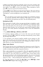
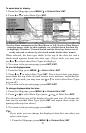
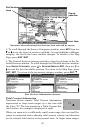
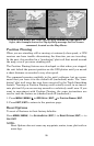
Navionics
Charts
Your GlobalMap 7000C can display Navionics
electronic charts on
MMCs. They work just like a MapCreate custom map on an MMC.
Left, entrance to Chesapeake Bay in a MapCreate 6 custom map,
10 mile zoom. Center, same position on Navionics chart at
11.15 mile zoom and right, 5.56 mile zoom.
To display a Navionics chart:
1. Install the Navionics MMC in the memory card compartment and
turn on the unit. (For full card install instructions, see Sec. 2.)
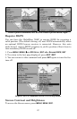
Steering
arrow
Speed