


ENGLISH
44
ENGLISH
General Information
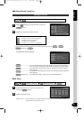
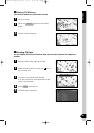
Detecting the vehicle’s position through the GPS
How the Vehicle’s Position is detected
* GPS stands for the “Global Positioning System”; it is a system for detecting an object’s
position through the use of the satellites of the Defense Department of the United States.
Radiowave signals from three or more satellites are received by the navigation system,
which utilizes the principle of triangulation to detect the position in which the radiowave
signals are received.
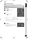
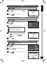
When the navigation unit is receiving the GPS radiowave signals, a “GPS” mark will appear
on the map screen.
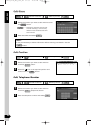
Detecting the vehicle’s position through self-contained navigation
* Self-contained navigation is a system that detects the vehicle’s position by calculating the
vehicle’s driven distance and turning angle though the use of various types of sensors that
are mounted on the vehicle.
Through the use of self-contained navigation, the vehicle’s position can be detected even in
an area where the GPS radiowaves signals cannot be received.
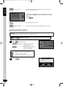
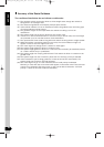
Making corrections to the detection of the vehicle’s position through map matching
* In map matching, the position information resulting from the detection of the vehicle’s
position and the locus of the travel of the vehicle up to the present are constantly compared
to the shapes of the roads on the map in order to correct the vehicle’s position mark to the
most appropriate road.
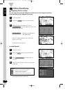
* If the vehicle is driven on a road whose actual shape differs from its map data, the vehicle’s
position mark on the map could deviate from its actual position.
Occasionally, the correction of the vehicle’s position mark to the actual road on the map can
be observed particularly after the vehicle has turned at an intersection or has come out of a
parking area.
DV2100_P1-BC_Eng_ver3_4E 01.8.6 12:01 PM Page 44