


PAGE7OF13
BT359_GPS_v1.2.1
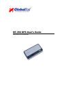
BT-359 GPS
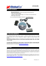
5. INITIALIZING YOUR GPS RECEIVER
Before using your Bluetooth GPS receiver for navigation (especially for the first time), the receiver must
obtain a local GPS fix (coordinates) of the current position. To do this, take your device loaded and
configured with your mapping software to an open area that has a clear view to the sky. Start your
software (or the included GPS Info utility program) and wait for initialization of the GPS to complete.
This may take a few minutes depending on various factors such as the distance of the current
coordinates from the last time the GPS receiver was activated, GPS signal strength and surrounding
terrain (tall trees and buildings can block the satellite signals). Once the RAW GPS data is displayed
onto the screen, if applicable for your software, a fix has been initialized (Green LED on the GPS will
also start to flash). In some cases initialization can take up to several minutes depending on the
conditions mentioned above before complete GPS data will be displayed on the screen.
Coordinates scrolling with zero’s means that the port connection is complete, but the satellite data is not
being received yet (possibly still initializing or in a bad area for satellite reception).
6. USING / TESTING YOUR GPS RECEIVER (WIN / PPC only)
Once your Bluetooth GPS receiver has been paired with your device and your personal mapping
software have been installed and the COM port configured properly, you can begin to use your
navigation system. If you don’t have a mapping, or navigation software to try out your new GPS
receiver, we’ve included a GPS test utilities called “GPS Info” (GPSInfo.exe) for Windows and Pocket
PC devices located in the Win directory and “GPS Utility” (Mac_GPS_Utiltiy_V2.dmg) is located in the
.Mac directory of the CD-ROM.
Both utilities can be download from our web-site www.USGlobalSat.com
Always select an area in the vehicle where the GPS unit will be secure and not obstruct normal driving,
visibility and safety, but still maintaining a “view to the sky” in order to receive satellite data.
WIN and PPC devices:
It is recommended that you first load and test your GPS receiver with the GPSinfo.exe. This process
will confirm you have found correct COM port number and have configured it properly.
1. Run GPSinfo.exe to load the utility.
2. Enter the proper COM port for your GPS device (see COM Port Verification above)
3. Set COM port to Baud rate: 34800
4. If no errors have been made in configuration, there should be GPS data being displayed in the
window, which is confirmation that the communication between the GPS device and the “GPSinfo”
software is working properly.
5. If there is no GPS data displayed (or data with multiple zeros in them), please exit the software and
unplug the GPS receiver from the USB port and reinsert it after 10 seconds to reset the device.