


4
190-00607-06 Rev D
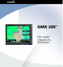
WSI Addendum
to select the altitude to display the reported informa-
tion.
The Icing and weather radar displays are mutually
exclusive, meaning one or the other may be displayed,
but not both at the same time. Turning the Icing dis-
play on turns off the weather radar display.
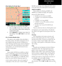
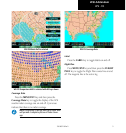
Temporary Flight Restrictions (TFRs)
Temporary Flight Restrictions (TFRs) indicate areas
where flight restrictions have been imposed. They are
depicted as areas with yellow outlines and a cross-
hatch pattern. The cross-hatch pattern indicates that
the TFR is currently active or within 30 minutes of
being active. The area may also contain the TFR identi-
fier. The TFR identifier includes the TFR number and
upper altitude. TFRs are displayed on the MAP func-
tion when Airspaces are enabled in the MAP function.
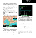
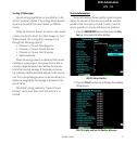
Menu Options for Overlay Page 2
1. Press the OVRL function key to allow selec-
tion of the Overlay choices when viewing the
Graphical WX option.
2. Press
MENU/ENT to display menu items for the
Overlay.
3. Press
MAIN MENU to return to the Main
Menu.
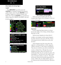
WSI FIS Graphic Weather Menu Items
Lightning
Press the Lightning key to toggle the display of
lightning strikes on and off.
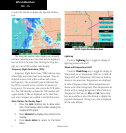
Winds and Temperatures Aloft
Press the Wind/Temp key to toggle the display of
Winds Aloft on, or Temperature Aloft on, or both off.
Winds Aloft and Temperature Aloft may not both be
shown at the same time. Temperatures are displayed
in units of degrees Celsius. Minus temperatures are
shown with a blue background. Plus temperatures are
shown with an orange background. When Winds or
Temperature Aloft are on, Alt+ and Alt- Menu Item
keys are available to select the altitude to display the
reported information. If Icing is on, data is displayed
for the same altitude.
WSI - FIS