


2
190-00607-06 Rev D
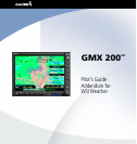
WSI Addendum
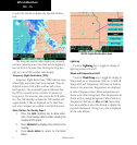
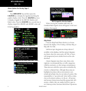
Graphical WX Overlay Options
A variety of graphical information is available with
the Overlay function when viewing the Graphical WX
display. Press the OVRL function key to view and
select available options. Some or all of the following
may be available, based on your FIS subscription.
• US and/or Canadian Weather Radar (determined
by subscription)
• METARs, US, and/or Canadian (determined by
subscription)
• SIGMETs & AIRMETs
• Echo Tops
• Icing
• TFRs
• Lightning
• Winds/Temperature Aloft
• Label
• Flight Plan
• Legend
• Map Detail
• Map Orientation
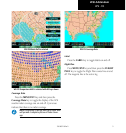
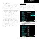
Graphical Weather (WX) Display
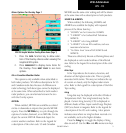
Weather radar images are available for display
from the FIS sensor by selecting the Graphical WX
option. A cyan dot pattern indicates areas where no
data has been received from the FIS sensor. Solid cyan
areas represent areas where the ground based weather
radars are unable to monitor weather. This is typically
caused by terrain obstruction. When depicted, color
coded weather intensity is presented and is an indica-
tion of radar echo return strength. Different colors
are used for US and Canadian weather. Because of
weather radar differences, do not assume that the same
actual weather intensities are represented by the same
colors. The intensities associated with the color codes
are available by viewing the Legend Overlay Option.
The legend associated with the weather radar image is
shown for the depicted radar data, US or Canadian.
The weather display and Icing products are
mutually exclusive. You may select to display either
the weather display or Icing, not both. Selecting the
weather display will turn off the Icing display.
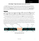
WSI FIS Graphic Weather Info
WSI - FIS