


12
Part Two: Section 2
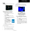
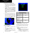
XM Weather
reports, Cell Movement, or Winds Aloft.
XM WPT Pages
WhenaGDL69orGDL69Aisinstalled,twoXM-
relatedpagesareaddedto“airport”pagesintheWPT
page group:
• Textual METAR Page.TheTextualMETAR
pageshowsthetextofthemostrecentMETAR
(MeteorologicalAerodromeReport)thathas
been received for an airport.
• TAF Page.TheTAFpageshowsthetextofthe
mostrecentTAF(TerminalAerodromeFore-
cast) that has been received for an airport.
XM AUX Pages
WhenaGDL69orGDL69Aisinstalled,thefol-
lowingXMpagesappearintheAUXgroupofpages:
• XM Audio Page(GDL69Aonly).SeeSection4
below for a description of this page.
• XM Information Page. This page contains
information that you will use when activat-
ingyourXMsatelliteradiosubscription.It
alsoreportstheGDL69/69A’ssoftwareversion
number.
• XM Weather Timestamps Page. This page
shows timestamp data for the most recently
receivedXMweatherdata.
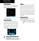
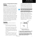
Section 2: XM Weather
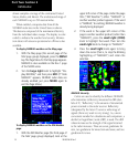
TheXMWeatherFunctioniscapableofdisplaying
graphicalweatherinformationthroughtheXMSatel-
liteRadioServicewhenactivatedintheoptionalinstal-
lationoftheGDL69/69A.NextGenerationWeather
Radar(NEXRAD),METARssymbols(METAR),
Lightning(LTNG),CellMovement(CELLMOVE),
andWindsAloft(WINDS)aredisplayedontheNAV
pages. The types of products available depend on the
subscriptionservicewithXMSatelliteRadio.
Once you have activated an aviation weather ser-
vicefromXMSatelliteRadio,the400W/500Wseries
unit can display the following aviation-related data:
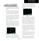
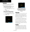
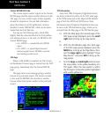
• NEXRAD. An indication of the intensity
of weather radar echoes from the National
WeatherService’snetworkofNEXRAD(NEXt
generationRADar)sitescanbeshownonthe
XMWeatherPageandcanoptionallybeover-
laidontheMappage.(Boththesepagesarein
the NAV page group.)
• Radar Coverage.WheneverNEXRADis
shown, a cross-hatch pattern indicates the limits
ofNEXRADradarcoverage.Thecross-hatched
areashowswhereNEXRADinformationis
unavailable.
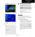
• Lightning (LTNG).
When enabled, lightning
strikesandcellsareshownasyellow“+”
signs.Lightninginformationindicatesthe
locationofcloud-to-groundlightningstrikes.
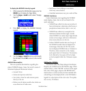
• Cell Movement (CELL MOVE). When
enabled, Cell Movement shows the storm
cells identified by the ground-based system.
The movement is depicted by an arrow. The
tip of the arrow represents where the cell is
expectedtobein10minutesfromthetime
the cell location was determined.
190-00356-30 Rev C