


26
Projecting a Waypoint
Projecting a waypoint from any map item (another
waypoint, etc.) allows you to establish a new waypoint on
a bearing and distance projected from that map item.
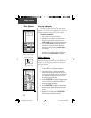
To project a waypoint:
1. Select a map item from the Find Menu.
2. Highlight the Option Menu on-screen button at
the top of the Information Page and press the
CLICK STICK to display the Project Waypoint Page.
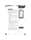
3. Press the CLICK STICK to display the numerical
keyboard for entering the distance. Move from
numeral to numeral pressing the CLICK STICK to
enter numbers.
4. Enter the distance and bearing to the projected
waypoint in the appropriate fi elds and then select
‘OK’ and press the CLICK STICK to complete.
Editing a Waypoint
You can personalize a Waypoint by changing the
Name fi eld and map Symbol fi eld to make them easier to
recognize or can change the coordinates or elevation. It
can also be deleted.
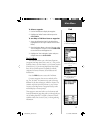
To edit a waypoint:
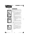
1. Use the Find Menu to display the waypoint.
2. Use the CLICK STICK to highlight the Waypoint
symbol fi eld and then press to display the symbol
list. Use the CLICK STICK to move up and down the
list to highlight a symbol and then press to place
the symbol in the symbol fi eld.
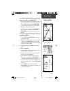
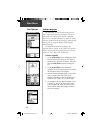
3. U
se the CLICK STICK to highlight the Waypoint name,
location coordinates or elevation fi elds
fi eld, and
then press to display the keyboard.
4. Use the CLICK STICK to highlight the desired charac-
ters and then press. Repeat the process until you are
through.
5. Highlight ‘OK’, and then press the CLICK STICK to
save the changes and close the keyboard.
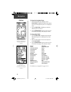
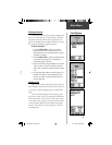
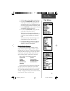
Main Menu
Mark Options
Enter Distance and
Bearing to Project a Waypoint
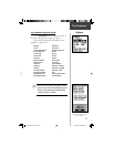
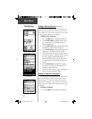
Using the keyboard to edit
Waypoint Name Field
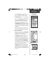
Waypoint Symbol Field
190-00234-00_0C.indd 26 10/11/2002, 9:49:25 AM