


14
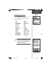
Setup Options
Map
Page Setup
Tracks Setup
Map Features Setup
Text Setup
(For defi nitions, see Appendix C, pages 54-55.)
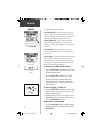
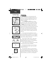
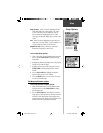
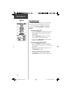
The ‘ Setup Map’ option displays the fi ve Map Setup
Pages, each accessed by an on-screen button. A list of
options displays for the features listed. Scale options
indicate the point at which Tracks, Tracks Logs, Map Fea-
tures, or Text Boxes are visible, allowing you to remove
map clutter and defi ne map features.
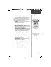
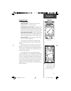
Page - Orientation:
‘ Track Up’ or ‘ North Up’;
fixes the
top of the map display to the current track heading
or to a north heading.
Auto Zoom:
On or Off;
automatically scales the map
to display both your current location and the next
point to which you are navigating.
Detail:
Most, More, Normal, Less, or Least;
controls
how much map detail you see. This setting only
applies to a map feature set to ‘Auto’. Those
features which have a specified scale or are turned
‘Off’ are unaffected by this setting.
Lock on Road:
On or Off;
available only if
MapSource Data is loaded; when ‘On’ the triangle
icon locks to the road that you are traveling
.
Display Mode:
Land or Water;
choice displays in
light color while the other displays in a dark color.
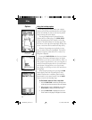
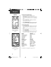
Tracks - Saved Tracks and Track Log:
Scale options;
‘Off’, ‘Auto’, or 20 ft.-500 miles, sets the maximum
scale at which the feature should appear on the
screen. Some types of data will display only to
certain zoom scales.
Goto Line:
Bearing or Course;
determines which
pointer displays.
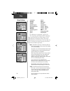
Sunrise
Sunset
Time of Day
To Course
Trip Odometer
Trip Time - Moving
Trip Time - Stopped
Trip Time - Total
Turn
Velocity Made Good
Vertical Speed
(Continued)
Final ETA
Final ETE
Heading
Maximum Speed
Moving Avg. Speed
Odometer
Off Course
Overall Avg. Speed
Pointer
Speed
190-00234-00_0C.indd 14 10/11/2002, 9:49:19 AM