


33
Part Three: Section 2
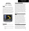
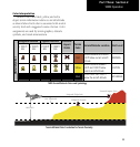
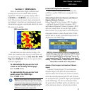
TAWS Operation
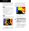
Color Interpretation
Garmin TAWS uses black, yellow, and red to
depict terrain information relative to aircraft altitude
as shown below. Each color is associated with an alert
severity level and a suggested course of action. Color
assignments are used by terrain graphics, obstacle
symbols, and visual annunciations.
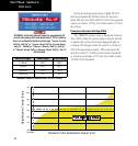
Unlighted Obstacle Lighted Obstacle Potential
Impact
Points
Terrain
Color
Terrain/Obstacle Location
Alert Level
< 1000 ft
AGL
> 1000 ft
AGL
< 1000 ft
AGL
> 1000 ft
AGL
Obstacle Symbol
Red
Terrain/Obstacle at or within
100 ft below current aircraft
altitude
WARNING
Yellow
Terrain/Obstacle between
100 ft and 1000 ft below
current aircraft altitude
CAUTION
Black
Terrain more than 1000 ft
below the aircraft altitude
NO DANGER
TAWS Terrain/Obstacle Colors and Symbology
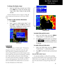
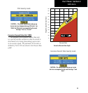
Potential Impact Point
Unlighted Obstacle
Projected Flight Path
1000' AGL
100' Threshold
Terrain Altitude/Color Correlation for Terrain Proximity