


7. CUSTOMIZING YOUR UNIT
7-3
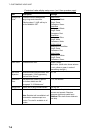
Contents of general setup menu (con’t from previous page)
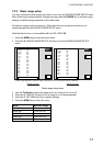
Item Description Settings
TD Display Chooses type of TD to display.
Loran C, Decca
Speed Chooses speed format to display. SOG (Speed over ground), STW (Speed
through water)
Position
Display
Chooses how to display position.
Examples of MGRS indications:
18S: Locating a point within the Grid
Zone Designation
18SUU: Locating a point within a
100,000-meter square
18SUU80: Locating a point within a
10,000-meter square
18SUU8401: Locating a point within a
1,000-meter square
18SUU836014: Locating a point within
a 100-meter square
Latitude, Longitude; Loran or
Decca TDs, or MGRS
(Military Grid Reference
System).
What is MGRS?
For convenience, the world is generally
divided into 6° by 8° geographic areas,
each of which is given a unique
identification, called the Grid Zone
Designation. These areas are covered by
a pattern of 100,000-meter squares.
Each square is identified by two letters
called tie 100,000-meter square
identification. This identification is unique
within the area covered by the Grid Zone
Designation. Exceptions to this general
rule have been made in the post to
preserve the 100,000-meter
identifications on mapping that already
exists.
A reference keyed to a gridded map of
any scale is made by giving the 100,000-
meter square identification together with
the numerical location. Numerical
references within the 100,000-mater
square are given to the desired accuracy
in terms of the easting (E) and northing
(N) grid coordinates for the point. The
Grid Zone Designation usually is prefixed
to the identification when references are
made in more than one grid zone
designation area.
Time Display Chooses time notation.
12 hours, 24 hours
(Con’t on next page)