


Black plate (64,1)
Cadillac Escalade/Escalade ESV Owner Manual - 2013 - CRC 2nd Edition - 10/
9/12
7-64 Infotainment System
Maps
This section includes basic
information that you need to know
about the map database.
The maps are stored on a compact
flash drive that is built into the
navigation system.
Detailed Areas
Road network attributes are
contained in the map database for
detailed areas. Attributes include
information such as street names,
street address, turn restrictions, etc.
A detailed area includes all major
highways, service roads, and
residential roads. The detailed areas
include points of interest (POI) such
as: restaurants, airports, banks,
hospitals, police stations, gas
stations, tourist attractions, historical
monuments, etc. The map database
may not include data for newly
constructed areas or map database
corrections that are completed after
the production of the compact flash
drive. The navigation system
provides full route guidance in the
detailed map areas.
Limited Guidance Areas
Any area that is not classified as
detailed, is a limited guidance area.
Limited guidance streets are
displayed on the map but route
guidance may not be given on these
streets. Some POI categories, such
as the city center POI category, and
some street addresses are included
in the limited guidance areas.
The navigation system informs
through voice prompts when you are
traveling into a limited guidance
area where route guidance is not
available. The street maps and the
directional arrow displayed on the
navigation system can then be used
to determine the remaining route to
your destination.
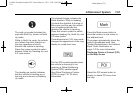
Map Adjustmen ts
The system lets you adjust the scale
of view on the map. Also, as you
drive, the map scrolls automatically
based on the direction of travel.
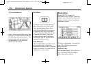
Map Scales
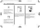
+ / − (Zoom In/Zoom Out): Press
the zoom in or out screen buttons or
the scale on the bar to change the
level of map detail. The scale
appears on the screen once the
zoom in or zoom out screen buttons
are selected. The system adjusts
the map accordingly. The scale of a
map can range from 1/32 mi (50 m)
to 256 mi (400 km). To change
English or metric, see Driver
Information Center (DIC) on
page 5‑23 for more information.