


I have a question …
What does “Geotagging” actually mean?
The term “geotagging” is sometimes also referred to as
“geocoding”.
Using “geotagging” e.g. photos, or videos, can be
complemented with geographical coordinates (latitude
and longitude, or physical address). This geographical
identification data is saved together with the photos.
Thereby photos can be assigned easily and explicitly to
maps like GoogleMaps, or can be viewed on Google
Earth.
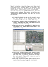
Via the locr web site the coordinates are determined by
manual geotagging. Together with the respective photo
they are stored in the locr data base.
The locr PC Client works differently. No matter whether
the coordinates have been associated using manual or
automatic geotagging, the information is written into the
EXIF
*
header of the photo. Suitable software can read
and use this information.
What is a datalog GPS receiver and how does it work?
A datalog GPS receiver is a device, which - as long as it is
switched on - continuously receives and logs (stores)
data concerning its current position.
The operating mode of a datalog GPS receiver is based
on the principle of the global satellite-based positioning
system (GPS).
GPS
GPS (Global Positioning System) uses satellites that
permanently emit their changing position and time. On
the basis of this information global positioning can be
generated.
GPS receivers
Based on the information emitted by the satellites GPS
receivers generate their own position. Therefore they
need the signals of at least three satellites.
*
Exchangeable Image File Format. Specification created by the Japan Electronic Industry
Development Association (JEIDA) for the image file format used by digital cameras header of the
photo.