


double-clicking the right mouse button (zoom out) makes
zooming much faster.
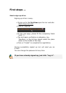
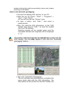
How to use automatic geotagging
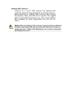
• Connect the datalog GPS receiver to your PC.
• Start the locr PC Client.: “Start” > “Programs” >
“locr” > “locr Client”.
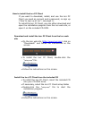
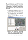
On the left you see the “Photos” area.
• To open a photo, click “Add...” and select a
photo/photos.
• Now, you need the GPS information. In the “GPS
Tracks” area click on “Add...” to read the needed
files from the datalog.
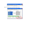
Matching photos will be marked green and the
calculated latitude and longitude will be displayed
in “()”.
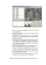
The position (latitude/longitude) has not yet been written into the
EXIF header. This will only happen if you click the “Automatic
geotagging” button.
• Then click “Automatic Geotagging”.
The locr software now automatically completes the
given photo data with the GPS information. The
information will be written into the EXIF header, the