


Ostia User Manual
Page 1
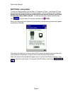
SECTION 1: Important Safety Instructions
For the safety of yourself and others, please observe the following safety
For the safety of yourself and others, please observe the following safety For the safety of yourself and others, please observe the following safety
For the safety of yourself and others, please observe the following safety
requirements:
requirements:requirements:
requirements:
! Do not attempt to operate a Pocket PC Navigator system in a vehicle while the
vehicle is in motion, or in any way that interferes with safe driving.
! Secure the iGPS receiver and Pocket PC to the vehicle in such a way as not to
endanger the driver or passengers during driving or operation.
! Do not use the Pocket PC and Ostia in any area (country, state, city, etc.) that
prohibits the use of electronic displays in motor vehicles.
! Navigation maps may contain errors and omissions or may be out-of-date with
recent road changes or road conditions. Please be attentive to roadway signage,
all posted roadway information, and the condition of the roads you are traveling.
! Routes generated by Ostia are only recommendations and are for personal and
non-commercial use.
! Ostia software and the iGPS receiver may not be used for any purpose in which
failure of the products could lead to personal injury, physical, or environmental
damage.
! Pharos and its suppliers specifically disclaim any warranties, either express or
implied, for their products’ fitness for use in any high-risk activities.
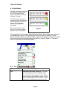
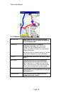
SECTION 2: Summary of Features
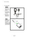
! Compatible with CompactFlash GPS receiver (NMEA-0183)
! Detailed street level mapping data.
! Mapping features include: location by address, intersection, location of area points
of interest or waypoint saved by user previously.
! Calculating route from one location to another, or selection of a street location on
the map.
! Opening up to 10 maps at a time.
! Driving directions and route guidance.
! Tapping the street on the map to show the street name.
! Zoom in and zoom out with stylus.
! Creating a user waypoint database.
! GPS status indicators.
! Simulating car navigation.
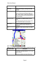
! When navigating with the iGPS receiver:
• Display the street name of the next turn at the bottom of screen.
• Show the distance to the next turn.
• Voice prompt for reliable route guidance.
• Second prompt before a turn or highway entrance/exit.
• Auto zoom-in before the turn or highway entrance/exit and zoom-out after.
• Use of the iGPS receiver position as the point of origin.
• A one-touch Re-route button.
• Navigation data such as speed, longitude, latitude, local time and direction
of travel.
• Auto re-route option.