


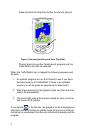
10
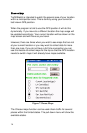
SR-84 is shown running between I-880 and US101 across the bay
waters to I-880, but the real road extends down to I-280 and up to I-
680 and beyond. The speed sensors show where the road goes
even though the map does not.
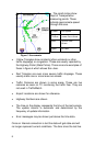
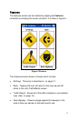
Locals can probably discern Lawrence Expy, San Tomas Expy,
Montague Expy, Tully Road, Capital Expy, Almaden Expy, Foothill
Expy, and Central Expy which all show speed data.
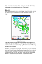
Using TrafficWatch
The ideal way to use TrafficWatch is with a live data connection all
of the time. If you use the program like this the map will change
automatically to show you information about the area you are near
so long as WayPoint is also running to provide the GPS input.
Another way to use this program is to collect data from home or
work and then grab the PDA unit as you leave. The data image will
be the latest one available and will likely still be able to provide you
with accurate information to use to make traffic decisions.
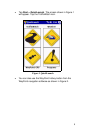
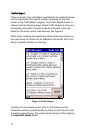
If you want more information about a particular incident you see on
the screen you can tap the incident and after a short delay a voice
will tell you about the incident if there is more information on it.
Sometimes there is no further information available. You can also
circle a group of incidents and the voice will tell you about all of
them.
For text of the incident data see the section titled Traffic Report on
page 12 for the Traffic Report.