


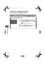


52
Before
Use
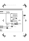
Getting
started
Routing
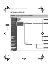
Address
Book
Voice
Recognition
If necessary
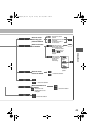
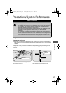
GPS is a position detecting system utilizing the signals
from GPS satellites deployed by the U.S. Department of
Defense. The Mobile Navigation System uses input from
three or more satellites and calculates the vehicle position
based on the principle of triangulation.
The positioning accuracy of the system corresponds to the
error display of the GPS which is from about 30 to 200 meters
.
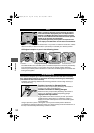
lIf you are using the system for the first time, or if you have not used it for some time, it takes
about 5 minutes (or about 2 minutes in open areas) to calculate your vehicle’s position.
nGPS signal reception is poor in the following places
lThe GPS satellites are controlled by the U.S. Defense Department, which may intentionally
lower positioning accuracy. In such cases, there may be vehicle position deviations.
lThere may be vehicle position deviations for some time until GPS signals are received after
turning on the ignition.
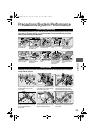
This function compares your vehicle’s tracking data with the road data on the map
disc, applies dead reckoning to determine the road you are driving on, and displays
your vehicle on that road on the map.
lIntelligent map matching addresses the following problems to achieve high accuracy in
vehicle positioning.
Position Correction for Elevated Roads
Position accuracy is improved by detecting if the vehicle is
running on or under an elevated road.
Position Correction for Parking Garages
Position accuracy is improved by detecting if the vehicle is
driving in an elevated or underground parking garage.
High-precision Gyrosensor
A gyro detects turns with an accuracy of 0.05° per second.
Combined with a speed sensor, it enables the system to
display the current vehicle position even where GPS signals
may be blocked.
lUsing a spare tire in place of the regular one may cause vehicle position deviations.
lAny difference between the direction which your vehicle actually travels and that shown on
the map is automatically eliminated by azimuth correction.
GPS
In tunnels
Among high-rise buildings
Under elevated roads In wooded areas
Map Matching
1%>(%C2%:-C)%FSSO4EKI8YIWHE]%TVMP41