


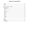
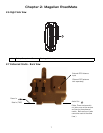
Chapter 1: Information
3
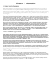
1.6 GPS Maps and Your Safety
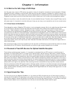
Remember, your GPS device is an aid to navigation. It must be used with common sense, and it is important that users
interpret GPS map data with a critical eye. Landscapes and roads change or may be impassable, trees and tall buildings can
obscure GPS signals, and your GPS device may not always reflect the complete picture. When using GPS, you must combine
the information provided by your GPS map with your relevant local knowledge, road signage, buoys, depth soundings and
changing local conditions to generate a complete understanding of your situation.
It is your responsibility to ensure compliance to all traffic laws, including pedestrian observance of crosswalks, and to use
good judgment while operating the Magellan GPS receiver. Safety must be your primary concern. The Magellan GPS receiver
must not be used while engaged in any activity requiring the user's full attention to the environment. For instance, the
Magellan RoadMate GPS receiver should be operated only by vehicle passengers or by the driver when the vehicle has come
to a complete stop. The driver must not attempt to view the display while driving. Disregard any unsafe, hazardous or illegal
route suggestions.
Magellan maps do not include, analyze, process, consider or reflect any of the following: legal restrictions (such as weight,
height, width, load and speed restrictions); road slope or grade; bridge height, width, weight or other limits; population
density; neighborhood quality or safety; availability or proximity of law enforcement, emergency rescue, medical or other
assistance; construction work zones or hazards; road, sidewalk, or waterway closures or conditions; weather conditions;
pavement characteristics or conditions; special events; traffic congestion; time of day.
*Thales Navigation licenses map data from governmental sources such as, but not limited to, U.S. Geological Survey
(USGS), the National Oceanic and Atmospheric Administration (NOAA-NOS) and the Canadian Hydrographic Service (CHS).
Thales Navigation also licenses map data from commercial cartography companies such as Navigation Technologies,
Navionics, DMTI and C-Map.