


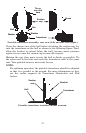


27
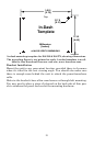
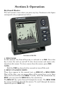
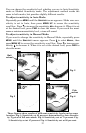
In the following figure, the screen shows a depth range from 0 to 80
feet and the bottom depth is 36.9 feet, shown by the digital sonar. The
water temperature is 34.5° F.
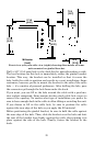
Full Chart page.
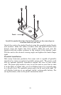
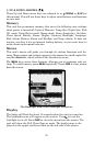
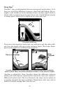
FasTrack
This feature automatically converts echoes to short horizontal lines on
the display's far right side. The rest of the screen continues to operate
normally. FasTrack gives you a rapid update of conditions directly un-
der the boat, making it useful for ice fishing or when fishing at anchor.
When the boat is not moving, fish signals are long, drawn out lines on a
normal display. FasTrack converts the graph to a vertical bar graph
that makes a useful addition to fishing at a stationary location.
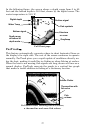
Full sonar chart showing surface clutter,
a thermocline and some fish echoes.
Fish symbols
Grayline
Bottom signal
Digital depth
Depth range
at bottom of
de
p
th scale
Surface signal
Water Temp
Structure
or cove
r
Surface Clutter
Thermocline with
fish echo
Fish
echoes