


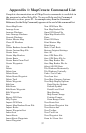

61
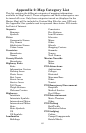
Appendix 2: Map Category List
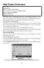
This list contains the different categories of mapping information
available in MapCreate 6. These categories and their subcategories can
be turned off or on. Only those categories turned on (displayed in the
Master Map) will be included in Custom Map Files for your GPS unit.
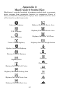
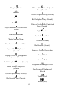
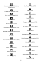
See Appendix 3 for symbols used to represent these items. POI stands
for Point of Interest.
Airports
Runways
Symbols
Cities
Community Names
City Names
Subdivision Names
Urban Areas
Countries
Boundaries
Names
County/Parish
Boundaries
Highway Exits
Exits
Information Centers
Parking Areas
Picnic Areas
Rest Areas
Scenic Areas
Service Areas
Toll Plazas
Weigh Stations
Welcome Centers
Highways
Interstate
Interstate Symbols
International Major
International Minor
State
State Symbols
US
US Symbols
Landmarks
Buildings
Cemeteries
Fire Stations
Land Features
Libraries
Mines
Other
Schools
Shopping Centers
Summits
Towers
Trail Names
Marine Navaids
Major
Minor
POI-Attractions
Auditoriums
Colleges
Historical
Museums/Zoos
Other
Tourist
POI-Emergency/Government
Hospitals
Medical Service
Post Offices
POI-Entertainment
Movie Theaters
Other
POI-Fishing
Bait/Tackle
Hatcheries/Lakes
POI-Lodging
Cabins
Camps/Campgrounds
Hotels/Motels