


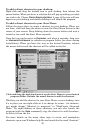
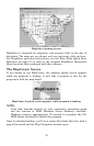
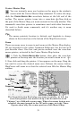

28
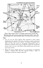
Master Map window shows a rectangle map border around Lake
Eufaula, along with a route, waypoints and event marker icons. The
Zoom Range is 50, which indicates that it's 50 miles across the map.
Tips:
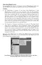
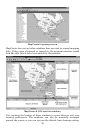
• You can use the Print Master Map command to print what's
displayed in the window. This lets you make a quick, customized,
paper backup map for your travels. (A prudent navigator never
relies on only one source of navigation information.) Due to
variances in monitor size, screen resolution, paper size and printer
drivers, what you see in the Master Map window may not fit your
paper page exactly.
• When your mouse pointer moves over a map feature or landmark
symbol, a Pop-up Tool Tip Box appears listing a name or
description of what the symbol represents.
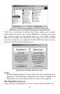
Event Marker Icon (boat ramp symbol)
Route
Line
Route
Waypoint
Waypoint
Map
Border
Border
Handle
Box
Zoom Buttons
Pan
Button
Zoom Range (miles)