


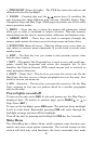
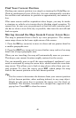

36
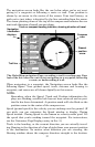
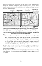
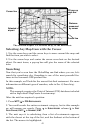
shape of a coastline or water body, but the higher detail in MapCreate
shows the shoreline completely and accurately (finer detail). Many
smaller islands would not be included in the background map, but are,
of course, in MapCreate.
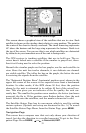
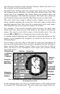
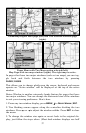
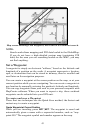
When the map is zoomed out far enough, most POIs appear as square
dots (left). As you zoom in closer, the symbols become readable icons.
In the 0.6-mile zoom example (right), the cursor has selected the Cupps
Café POI, which triggers a pop-up box with the POI name. This pop-up
box works on POIs at any zoom range.
Tip:
In some urban areas, businesses are so close to one another that
their POI icons crowd each other on the screen. You can reduce
screen clutter and make streets and other map features easier to
see by simply turning off the display of POIs you're not watching
for. (To see how, check the text on Map Detail Category Selection,
page 85. It shows how to use the Map Categories Drawn menu to
turn individual POI displays off and on.)
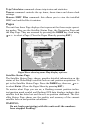
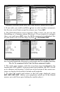
The Map Page has its own menu, which is used for several functions
and for setting various options. To access the Map Page Menu, from the
Map Page, press
MENU.
The Pages Menu also offers several map display options under the Map
Page category. To access them, press
PAGES|← or→ to MAP|↓ to Op-
tion|
EXIT.
School POI
Restaurant
POI
POI
Mar
k
er
Cursor line
Interstate
Major Street
Minor
Streets
Zoom Range
POI Pop-up,
with position,
distance and
bearing data