


35
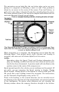
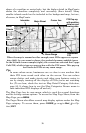
If you're using only the factory-loaded background map, the maximum
zoom range for showing additional map detail is 20 miles. You can con-
tinue to zoom in closer, but the map will simply be enlarged without
revealing more map content (except for a few major city streets.) Load
your own high-detail custom map made with MapCreate, and you can
zoom in to 0.05 miles with massive amounts of accurate map detail.
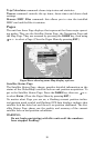
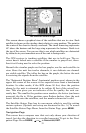
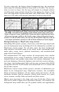
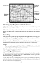
Map Pages with high-detail MapCreate map of an urban area loaded on
the MMC. Arterial streets appear at the 6-mile zoom range with a few
Point of Interest icons visible (left). Numerous dots representing Points
of Interest become visible at the 3-mile range, along with minor streets
(center). At the 0.6-mile zoom, you can see an interstate highway with an
exit, major and minor streets as well as Point of Interest icons (right).
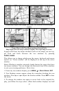
Background map vs. MapCreate map content
GlobalMap HD models contain a hard drive with full map detail built
into the background map (including all of the information available in
MapCreate custom maps). For all other units, the basic background
map includes: low-detail maps of the whole world (containing cities,
major lakes, major rivers, political boundaries); and medium-detail
maps of the United States.
The medium-detail U.S. maps contain: all incorporated cities; shaded
metropolitan areas; county boundaries; shaded public lands (such as
national forests and parks); some major city streets; Interstate, U.S.
and state highways; Interstate highway exits and exit services informa-
tion; large- and medium-sized lakes and streams; and more than 60,000
navigation aids and 10,000 wrecks and obstructions in U.S. coastal and
Great Lakes waters
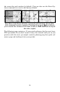
MapCreate custom maps include massive amounts of information not
found in the background map. MapCreate contains: the searchable
Points of Interest database, all the minor roads and streets, all the
landmark features (such as summits, schools, radio towers, etc.); more
rivers, streams, smaller lakes and ponds and their names.
What's more important is the large scale map detail that allows your
GPS unit to show a higher level of position accuracy. For example, the
background map would show you the general outline and approximate