


35
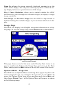
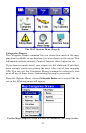
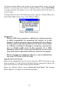
The iWAY Options Menu (Page 2).
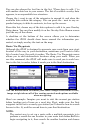
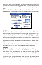
Categories Drawn
The Categories Drawn command lets you choose how much of the map-
ping detail available in our database you want shown on the screen. This
information includes contacts, Points of Interest, cities, highways, etc.
If you draw too much detail, your screen can feel cluttered. If you don't
draw enough, you're not getting the most value out of your mapping
GPS. You can use the Categories Drawn command to selectively turn
on or off any of these items, customizing the map to your needs.
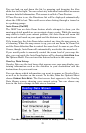
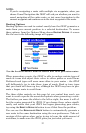
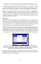
From the Options Menu, choose
CATEGORIES DRAWN and a screen like the
one in the following image will appear.
Use the Map Categories Drawn screen to customize your map. In this