


GM-82 User’s manual
8
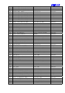
4.1.2 Geographic Position with Latitude/Longitude(GLL)
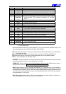
Table 4-4 contains the values for the following example:
$GPGLL,3723.2475,N,12158.3416,W,161229.487,A*2C
Table 4-4 GLL Data Format
Name Example Units Description
Message ID $GPGLL GLL protocol header
Latitude 3723.2475 ddmm.mmmm
N/S Indicator N N/S Indicator N N=north or S=south
Longitude 12158.3416 dddmm.mmmm
E/W Indicator W E=east or W=west
UTC Position 161229.487 hhmmss.sss
Status A A=data valid or V=data not valid
Checksum *2C
<CR> <LF> End of message termination
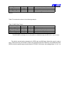
4.1.3 GNSS DOP and Active Satellites (GSA)
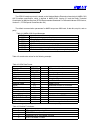
Table 4-5 contains the values for the following example:
$GPGSA,A,3,07,02,26,27,09,04,15, , , , , ,1.8,1.0,1.5*33
Table 4-5 GSA Data Format
Name Example Units Description
Message ID $GPGSA GSA protocol header
Mode 1 A See Table 5-6
Mode 2 3 See Table 5-7
Satellite Used
(1)
07 Sv on Channel 1
Satellite Used
(1)
02 Sv on Channel 2
…… ….
Satellite Used
(1)
Sv on Channel 12
PDOP 1.8 Position Dilution of Precision
HDOP 1.0 Horizontal Dilution of Precision
VDOP 1.5 Vertical Dilution of Precision
Checksum *33
<CR> <LF> End of message termination
1. Satellite used in solution.
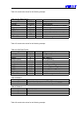
Table 4-6 Mode 1
Value Description
M Manual—forced to operate in 2D or 3D mode
A 2DAutomatic—allowed to automatically switch 2D/3D
Table 4-7 Mode 2
Value Description
1 Fix Not Available
2 2D
3 3D
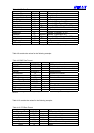
4.1.4 GNSS Satellites in View (GSV)
Table 4-8 contains the values for the following example:
$GPGSV,2,1,07,07,79,048,42,02,51,062,43,26,36,256,42,27,27,138,42*71
$GPGSV,2,2,07,09,23,313,42,04,19,159,41,15,12,041,42*41