


GM-82 User’s manual
7
4. Software Interface
The GPS-82 interface protocol is based on the National Marine Electronics Association's NMEA 0183
ASCⅡinterface specification, which is defined in NMEA 0183, Version 2.2 and the Radio Technical
Commission for Maritime Services (RTCM Recommended Standards For Differential Navstar GPS Service,
Version 2.1, RTCM Special Committee No.104).
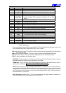
4.1 NMEA Transmitted Messages
The default communication parameters for NMEA output are 4800 baud, 8 data bits, stop bit, and no
parity.
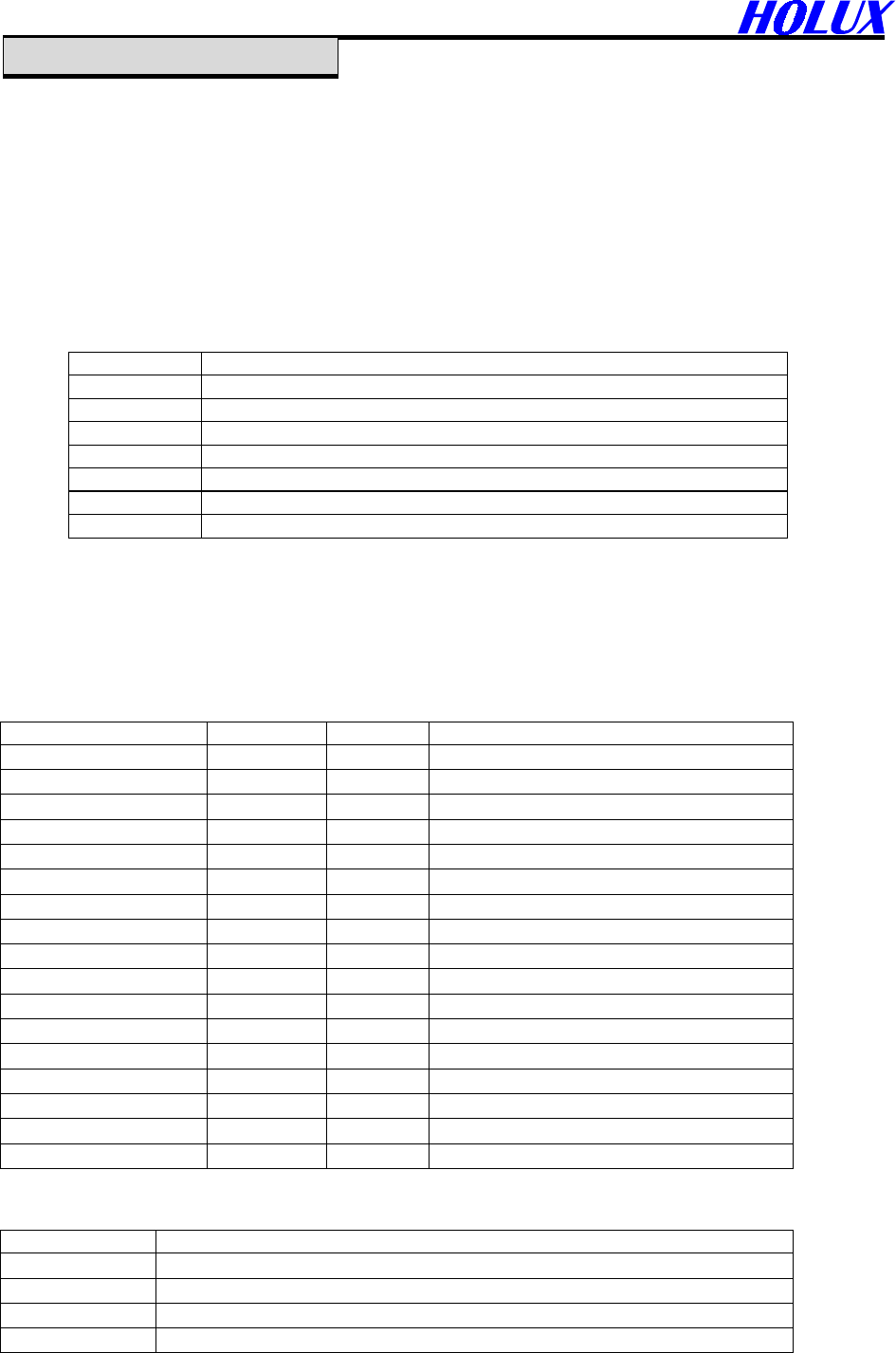
Table 4-1 NMEA-0183 Output Messages
NMEA Record
Description
GPGGA Global positioning system fixed data
GPGLL Geographic position- latitude/longitude
GPGSA GNSS DOP and active satellites
GPGSV GNSS satellites in view
GPRMC Recommended minimum specific GNSS data
GPVTG Course over ground and ground speed
GPMSS Radio-beacon Signal-to-noise ratio, signal strength, frequency, etc.
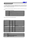
4.1.1 Global Positioning System Fix Data (GGA)
Table 4-2 contains the values for the following example:
$GPGGA,161229.487,3723.2475,N,12158.3416,W,1,07,1.0,9.0,M, , , ,0000*18
Table 4-2 GGA Data Format
Name Example Units Description
Message ID $GPGGA GGA protocol header
UTC Time 161229.487 hhmmss.sss
Latitude 3723.2475 ddmm.mmmm
N/S Indicator N N=north or S=south
Longitude 12158.3416 dddmm.mmmm
E/W Indicator W E=east or W=west
Position Fix Indicator 1 See Table 5-3
Satellites Used 07 Range 0 to 12
HDOP 1.0 Horizontal Dilution of Precision
MSL Altitude
(1)
9.0 Meters
Units M Meters
Geoid Separation
(1)
Meters
Units M Meters
Age of Diff. Corr. second Null fields when DGPS is not used
Diff. Ref. Station ID 0000
Checksum *18
<CR> <LF> End of message termination
(1). SiRF Technology Inc. does not support geoid corrections. Values are WGS84 ellipsoid heights.
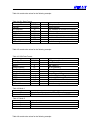
Table 4-3 Position Fix Indicator
Value Description
0 0 Fix not available or invalid
1 GPS SPS Mode, fix valid
2 Differential GPS, SPS Mode, fix valid
3 GPS PPS Mode, fix valid