


14 GPS 72H Owner’s Manual
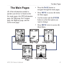
The Main Pages
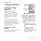
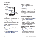
Map Page
Map Page
Data
Fields
Position
icon
Zoom
scale
Map
pointer
Your position on the map is
represented by (position icon). As
you travel, the position icon leaves a
track log (trail). Waypoint names and
symbols are also shown on the map.
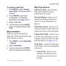
NOTE: Press OUT to zoom out or
IN to zoom in.
To view the map with north up:
1. From the Map page, press
MENU.
2. Select
Setup Map > General >
Orientation > North Up.
To clear a track log:
1. From the Main Menu, select
Tracks > Clear.
2. Select
Yes.
As you move the map pointer on the
Map page, the distance, bearing, and
location of the map pointer appear at
the top of the map.
To measure the distance
between two map points:
1. From the Map page, press MENU
> select Measure Distance.
2. Move the map pointer to another
location on the map. The total
distance between the two points
appearsinthedataelds.
To change the data elds on the
Map page:
1. Press MENU > select Setup
Page Layout.
2. Select the size and number of
rowsofdataeldsyouwantto
show on the map.